

By George Beccaloni & Paul Whincup
(New version published July 2019)
Ternate "is one of the most important places in the intellectual history of the world" Redmond O’Hanlon, 2009/10
"Wallace's Ternate house is the most important science history heritage site in Indonesia." Prof. Sangkot Marzuki (President of the Indonesian Academy of Sciences) & Syamsir Andili (former Ternate Mayor), 2015
CLICK HERE for a short video I made about the site of Wallace's Ternate house.

Ternate at sunset, 2012. © George Beccaloni.
The “earthquake-tortured island of Ternate” (as Wallace called it in his famous book The Malay Archipelago) is a small Indonesian island off the western coast of the much larger island of Halmahera. It consists of a very large active volcano (Mount Gamalama, 1,715 m) which is only inhabited around the base and is forested all the way to near the crater. Wallace made Ternate his base during the second half of his collecting expedition to the 'Malay Archipelago' and rented a house there and lived in it on several occasions between early January 1858 and early January 1861. It was whilst he was living there in March 1858 that he famously posted his essay on evolution by natural selection1 to Charles Darwin, and it is because of this that his Ternate house has become legendary.
In his book The Malay Archipelago Wallace writes the following about the house:
"On the morning of the 8th of January, 1858, I arrived at Ternate, the fourth of a row of fine conical volcanic islands which skirt the west coast of the large and almost unknown island of Gilolo [Halmahera]. The largest and most perfectly conical mountain is Tidore, which is over four thousand feet high--Ternate being very nearly the same height, but with a more rounded and irregular summit. The town of Ternate is concealed from view till we enter between the two islands, when it is discovered stretching along the shore at the very base of the mountain. Its situation is fine, and there are grand views on every side. Close opposite is the rugged promontory and beautiful volcanic cone of Tidore; to the east is the long mountainous coast of Gilolo, terminated towards the north by a group of three lofty volcanic peaks, while immediately behind the town rises the huge mountain, sloping easily at first, and covered with thick groves of fruit trees, but soon becoming steeper, and furrowed with deep gullies. Almost to the summit, whence issue perpetually faint wreaths of smoke, it is clothed with vegetation, and looks calm and beautiful, although beneath are hidden fires which occasionally burst forth in lava-streams, but more frequently make their existence known by the earthquakes which have many times devastated the town.
Ternate, 2018. © George Beccaloni.I brought letters of introduction to Mr. Duivenboden [Maarten Dirk van Renesse van Duivenbode], a native of Ternate, of an ancient Dutch family, but who was educated in England, and speaks our language perfectly. He was a very rich man, owned half the town, possessed many ships, and above a hundred slaves. He was, moreover, well educated, and fond of literature and science--a phenomenon in these regions. He was generally known as the king of Ternate, from his large property and great influence with the native Rajahs and their subjects. Through his assistance I obtained a house2, rather ruinous, but well adapted to my purpose, being close to the town, yet with a free outlet to the country and the mountain. A few needful repairs were soon made, some bamboo furniture and other necessaries obtained, and, after a visit to the Resident and police magistrate, I found myself an inhabitant of the earthquake-tortured island of Ternate, and able to look about me and lay down the plan of my campaign for the ensuing year. I retained this house for three years, as I found it very convenient to have a place to return to after my voyages to the various islands of the Moluccas and New Guinea, where I could pack my collections, recruit my health, and make preparations for future journeys…
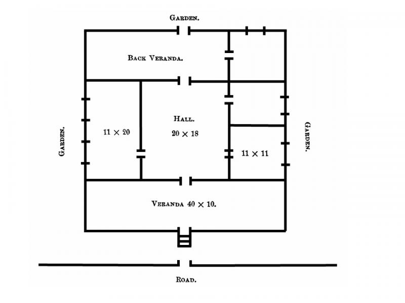
Floor plan of the Ternate house from The Malay Archipelago. Measurements are in feet.
A description of my house (the plan of which is here shown) will enable the reader to understand a very common mode of building in these islands. There is of course only one floor. The walls are of stone up to three feet high; on this are strong squared posts supporting the roof, everywhere except in the verandah filled in with the leaf-stems of the sago palm, fitted neatly in wooden framing. The floor is of stucco, and the ceilings are like the walls. The house is forty feet square, consists of four rooms, a hall, and two verandahs, and is surrounded by a wilderness of fruit-trees. A deep well supplied me with pure cold water--a great luxury in this climate. Five minutes’ walk down the road brought me to the market and the beach, while in the opposite direction there were no more European houses between me and the mountain. In this house I spent many happy days. Returning to it after a three or four months’ absence in some uncivilized region, I enjoyed the unwonted luxuries of milk and fresh bread, and regular supplies of fish and eggs, meat and vegetables, which were often sorely needed to restore my health and energy. I had ample space and convenience for unpacking, sorting, and arranging my treasures, and I had delightful walks in the suburbs of the town, or up the lower slopes of the mountain, when I desired a little exercise, or had time for collecting...
Just below my house is the fort, built by the Portuguese, below which is an open space to the beach, and beyond this the native town extends for about a mile to the north-east. About the centre of it is the palace of the Sultan, now a large untidy, half-ruinous building of stone."

The key information which might enable the location of the house to be located is as follows:
1) The house was just above the fort.
2) The market and beach were five minutes walk away.
3) The Sultan's palace was about half a mile to the north-east of the house.
The house itself, if it survives, might be identifiable by having the structure and floor plan that Wallace described, and the fact that there was a deep well in the garden (whether behind or to one side of the house he doesn't say). However, Wallace himself seems to suggest that the construction of the house was normal for that area, and its floor plan may not be unusual either. Interestingly, de Clercq (1890) states that "There is a clear shortage of good drinking water in the capital. The wells have been dug too close to the beach and not deep enough—as a result, there is always salt in the water. It does not bother the natives, though, and even the Europeans become used to it after a while, so nobody wants to take the trouble and spend the money needed to dig a deeper well somewhere on the slope of the mountain." This suggests that deep wells were probably uncommon, so the presence of such a well may be important additional evidence for determining the site of the house.
The general location of the house
In the mid 19th century when Wallace rented his house, the island and the whole of the surrounding region was controlled by the Dutch. The centre of Ternate town, where the Dutch lived, was to the south of "Benteng Oranje" (which has also been called Fort Oranje, Fort Orange or Castle Orange)3. This is the only fort situated about half a mile south of the Sultan's palace. All the other old forts south of the palace are a considerable distance away at the southern end of the island. In any case, we know that Wallace must have been talking about Fort Oranje as he says that beyond the fort "the native town extends for about a mile to the north-east" and this exactly corresponds with de Clercq's description in his 1890 book.
As stated above, Wallace stated that the fort was "Just below" his house, which narrows down the location considerably, as the only area adjacent to the fort where a one-story house would be *above* the fort's ramparts is to the west and south-west of the fort. Houses on the other three sides of the ramparts would have been *below* them.
A map of the fort area, drawn around 1810 (see below), shows that there was no road and no buildings directly to the west of the fort at that time. Although a map of the area published in de Clercq's 1890 book (see below) shows that a road had been constructed to the west of the fort, De Clercq says that the area behind the fort was a field used as a "drill ground", so it is very unlikely that there were houses between it and the fort. We can therefore probably discount the road running north-south along the western edge of the fort as being the location of Wallace's house.
The area which fits these constraints is that shown within the red square marked on the map below.
This area also agrees with Wallace's statements that his house was "close to the town, yet with a free outlet to the country and the mountain." and that "there were no more European houses between me and the mountain." The latter statement suggests Wallace's house was on the northern edge of the Christian quarter, which is where this area is located. Wallace's comment that his house was "surrounded by a wilderness of fruit-trees" also suggests it was on the edge of town, and furthermore that that the area between the fort and the north side of Jalan MT Habib Abubakar Al Attas at its western end, can be discounted as a possible site, as the garden area would have been small.

Detail of c. 1810 map showing Fort Oranje. [Ternate was occupied by British forces in 1810 before
being returned to Dutch control in 1817. Note the British flag in the fort].

Satellite image of Ternate taken in 2010 showing the most likely area where Wallace's house was sited.
The Santiong house
In 2008 a group of Indonesian academics and local residents identified a house plot owned by a Chinese family on the north side of Jalan Juma Puasa as being the most likely location of Wallace's house (Marzuki, 2008; Marzuki & Andili, 2015). We will refer to this as the "Santiong house". The house that is now on the plot is a modern construction, so if this plot was indeed the site of Wallace's house then the original dwelling no longer exists (not surprisingly, as we know that Wallace's house was made from wood, atap (the bases of Sago palm fronds) and thatch, which would all have rotted away a very long time ago). Their reasons for choosing this site were based on the fact that its location agrees with Wallace's statements that (i) it would have taken about 5 minutes to walk to the old market and beach (550 m from the house); and (ii) the Sultan's palace is about half a mile to the north4. However, the main factor in their decision seems to have been that the Santiong house has a large well on its western side (now capped with concrete). At that time no other old wells were known from the area to the north of Jalan Juma Puasa, so their conclusion that this was the most likely site seemed an entirely reasonable one.

Part of de Clercq's 1890 map showing location of various sites.

The Santiong house, the proposed site of Wallace's house. © George Beccaloni.

Nicholas Hughes beside the concreted well of the Santiong house in 2010. Photo: Nicholas Hughes.
The Oranje house
In 2012 the first author (George Beccaloni) visited the Santiong house and realised that its location did not agree with one very important statement which Wallace made i.e. that the fort was "Just below" his house. The land in front of the Santiong house slopes southwards down and away from the fort. To get to the fort one needs to exit the house, turn left, walk downhill to Jalan Merdeka, turn left and walk uphill to the south-west corner of the fort. In view of this, George argued that the Santiong house was not the correct site and that the actual location was more likely to have been on the west side of Jalan Merdeka opposite the south-west corner of the fort (see the video HERE). This site was located a few meters to the north of the top right corner of the area of land marked on the map above, i.e. an area where a house would have been above the fort; 5 minutes walk from the old market and beach; and about half a mile to the south of the Sultan's palace. Local residents, however, disagreed with this suggestion, pointing out that the only old well in the area was the one beside the Santiong house. They also argued that there were remains of an old fort directly across the road from this house, so it was indeed located "Just above" a fort.
In 2018 the authors asked local resident Pak Muhdi Aziz to conduct a survey of all the old wells in the area. A total of six were located, not including the one already known beside the Santiong house. One of the wells (no. 5 on the map below) was in the grounds of a property a few meters south of the site that George suggested in 2012, so given that this site would fit Wallace's description of his house's location better than the Santiong house and all the other sites in the area with old wells, we conclude that this is the most likely site of Wallace's house based on the available evidence. Research into the old walls across the road to the Santiong house revealed that they were not the remains of a hitherto undocumented fort as some believed, but rather the remains of a wall which formed the northern boundary of the old Christian Quarter5.

Map showing location of old wells (blue dots) and sites of the Santiong ("Santiong") and Oranje ("ARW") houses. Produced by Paul Whincup, 2019.

Locations of the Santiong and Oranje houses. Produced by Paul Whincup, 2019.
At the time Wallace was renting his house, Jalan Pipit to the north of the Oranje house plot did not exist. A house on that site would have faced towards the fort, with the well in the back garden. It is likely that this property was the last house before the Oranje Field (military drill ground) to the west of the fort. Evidence suggests that the original house plot was subdivided into two plots, with the well (recently capped with concrete) inside a recent house on the western plot near the mosque. The eastern plot appears to be vacant and the owner is currently unknown.

Location of the Oranje house as indicated by "Well No. 5", relative to Fort Oranje. This view is looking west over the fort to Mt Gamalama. Copyright Sinclair Stammers.
A summary of our arguments is as follows:
1) The Santiong house plot cannot be the correct location of Wallace's house as there is no fort "Just below" it.
2) Given that Wallace's house was sited just above a fort and the only fort in the area is Fort Oranje, it must have been on the western side of Jalan Merdeka opposite Fort Oranje, since houses on the other three sides of this fort would be below the fort ramparts.
3) There are good reasons to believe that there were no buildings along the western side of what is now Jalan Merdeka in Wallace's time, since the area to the west was a field used as a military drill ground. Also no old wells are known to the north of Well 5 along this road, supporting the idea that there were no old houses along it.
4) Given that the plot on which Well 5 is located is the only housing plot with a well in the only area which would have had houses higher than the fort, it is very probable that this is the site of Wallace's house.
The Sultan's house
An old house owned by the Sultan of Ternate's family has been claimed by some as being Wallace's house since it vaguely resembles it in its construction (see blog posts HERE , HERE and HERE). However, the house is nowhere near a fort, is in the "native town", and is much too close to the palace (see satellite image above), so it can be discounted as being Wallace's. In addition, the porch of it is supported by concrete columns (as in the photo below), a feature not mentioned by Wallace as being part of his house. It has an old well, but this is shallow (2 meters), not "deep" as Wallace describes.
Note that there is another well preserved old house which has a very similar construction to the Sultan's house not far from Fort Oranje to the north-west (it would have been in the "native town"). The red marker on the map below shows the position of this house.


Verandah of old house north-west of the fort (left) and map showing the location of the house (right).
Efforts to commemorate Wallace and his house
On 3 December 2008 the name of the road beside the Santiong house was changed from Jalan Nuri to Jalan Alfred Russel Wallace. In 2010, however, it was renamed Jalan Juma Puasa (Friday Fasting), and the alleyway beside the western side of the house was named "Lorong A. Wallace" instead.

Nicholas Hughes and the Jalan ARW sign in 2010. Photo: Nicholas Hughes.

Bill Bailey at the entrance to Lorong A. Wallace in 2012. © George Beccaloni.
There is currently (2018) a poster featuring Wallace in Jalan Branjangan to the west of the Santiong house. Wallace was included on the request of the mayor of the Santiong District, which the Santiong house and the Oranje house are situated in.

Poster on Jalan Branjangan, 2018. © George Beccaloni.
Future prospects
Given the international historical significance of Wallace's house and it's great tourism potential for Ternate, it is to be hoped that the likely site of his house which we have identified can be purchased and a replica of the original house built on the site. The house could house a museum about Wallace and his assistant Ali, who moved to Ternate, and explain the huge intellectual achievements Wallace made in Indonesia (natural selection, the Wallace Line etc) and the important role Ali played in Wallace's endeavours. It could also include displays about Indonesian biodiversity which Wallace helped so much to document, with much help from his many local assistants, and information about important conservation efforts to preserve Ternate’s natural heritage.
Acknowledgements
Many thanks to Pak Muhdi Aziz for information about the old wells, and Nicholas Hughes, Kirk Warren, and David Parry for their helpful input. We also thank Prof. Sangkot Marzuki, Syamsir Andili and Dr. Ahmad Nadjib Aziz for their pioneering work in locating the site of the house.
Endnotes
1. Although Wallace’s essay was marked as having being written on Ternate in February 1858, this cannot have been the case since Wallace’s unpublished Malay Field Journal in the Linnean Society of London shows that he was on Gilolo [Halmahera] during the whole of February, only returning to the neighbouring island of Ternate on 1 March. It is probable that he wrote “Ternate” on the essay simply because this was the island where he had his base, and because it was his postal address. Alternatively, he got the month wrong and should have written “March” instead of “February.” However, this would have been a curious error to make as he wrote a letter to Frederick Bates which he dated 2nd March 1858 (original in The Natural History Museum, London, catalogue number WP1/3/42). Why he never corrected either the date or the place of his discovery in his published accounts of this event is odd. For more information see http://wallacefund.info/content/dodinga-birthplace-wallaces-theory-natural-selection For details about Wallace's discovery of natural selection see http://wallacefund.info/en/biography-wallace
2. We know that Wallace's landlord was Chinese, because Wallace writes on page 11 of volume 2 of The Malay Archipelago "Soon after my first arrival in Ternate I went to the island of Gilolo, accompanied by two sons of Mr. Duivenboden, and by a young Chinaman, a brother of my landlord, who lent us the boat and crew." Note that Maarten van Duivenbode had a Chinese wife (Gim Nio), so Wallace's landlord may have been related to her.
3. Note that Fort Oranje is a Dutch fort - not Portuguese as Wallace stated. However, in the revised 1894 edition of Wallace's book Australasia it says that the fort was reputed to have been built on "the foundations of an old Portuguese structure".
4. Wallace says the "native town" with the palace at its centre was to the north-east, but the palace is actually slightly to the north-west of this house, so he seems to have made a mistake.
5. Local people have suggested that there was an old Portuguese fort on the opposite side of the road to the Santiong house, but that it was largely torn down for building material or was destroyed in WWII. However, if we examine de Clercq's map of 1890 or the map of 1810 (see above), there is no fort shown in that location. Any Portuguese forts would have been built around 1600, yet on this map of 1622 there is no other fort near Fort Malay (which became Fort Oranje): http://www.atlasofmutualheritage.nl/en/Sketch-map-showing-Malaya-Taluco-Calamatta-forts-on-Ternate.6257 This disproves the notion that a 'Portuguese fort' ever existed near Fort Oranje. In any case, Wallace referred to the fort near his house as "the fort" which indicates that it was the only fort, or at least the principal fort in the area i.e. it must have been Fort Oranje he was referring to. Also the fact that he says that the "native town" was north of the fort, and that below the fort was "an open space to the beach" also means it must have been Fort Oranje (any fort opposite the Santiong house would have had houses between it and the beach).
References
De Clercq, F. S. A. 1890. Bijdragen tot de kennis der residentie Ternate. Leiden: Brill. [See an English translation HERE]
Marzuki, S. 2008. Surat dari Ternate. Tempo: 140-141.
Marzuki, S. & Andili, S. 2015. The Ternate of Alfred Russel Wallace. In: Supriatna, J., Amarasinghe, A. A. T. & Margules, C. (Eds). Proceedings of the Second International Conference on Alfred Russel Wallace and the Wallacea. Taprobanica, 7(3): i-x.